
2026 Super El Niño Forecast: Global Storms and Record Heat Ahead
It’s shaping up to be a wild ride for the next two years. The National Oceanic and Atmospheric Administration has issued a stark warning: there is a 61 percent chance that a "super El Niño" will emerge by mid-2026. This isn’t your average warm spell. We’re talking about sea surface temperatures in the tropical Pacific spiking by at least 3.6 degrees Fahrenheit—four times the threshold of a standard event. For context, that kind of heat energy doesn’t just sit there; it rewires global weather patterns, bringing chaos from coast to coast.
The timeline is tightening. As of May 22, 2026, the Pacific is currently in a neutral state, but the calm is deceptive. Long-range models from the European Centre for Medium-Range Weather Forecasts suggest this could be the strongest El Niño in over a century. If the forecasts hold, we’re looking at a phenomenon that peaks between November and January, potentially pushing 2027 global air temperatures to unprecedented highs.
What Makes a 'Super' El Niño Different?
To understand why meteorologists are losing sleep, you have to look at the numbers. A normal El Niño requires sea surface temperatures to rise by just 0.9 degrees Fahrenheit above average. The projected 3.6-degree spike for 2026 is massive. It’s like turning up the thermostat on the entire planet’s engine room.
Historically, these events are rare beasts. Since systematic monitoring began, we’ve recorded 28 El Niño events. Only three were classified as "very strong." The last comparable giants hit us during 1982-83, 1997-98, and 2015-16. Those weren’t just bad weather years; they were global disruptors. The 1997-98 event alone caused billions in damages worldwide, triggering floods in Peru, droughts in Australia, and record-breaking warmth globally.
Here’s the thing: El Niño–Southern Oscillation (ENSO) is a natural cycle. It’s the heartbeat of the climate system. But when that heartbeat goes into ventricular fibrillation, everyone feels it. The warm phase (El Niño) weakens the trade winds that usually blow from east to west across the Pacific. When those winds falter or reverse, warm water sloshes back toward the Americas, altering jet streams and storm tracks across the globe.
Regional Impacts: Who Gets Wet, Who Gets Dry?
The impacts aren’t evenly distributed. In fact, they’re often opposites. While some regions brace for deluges, others stare down searing droughts.
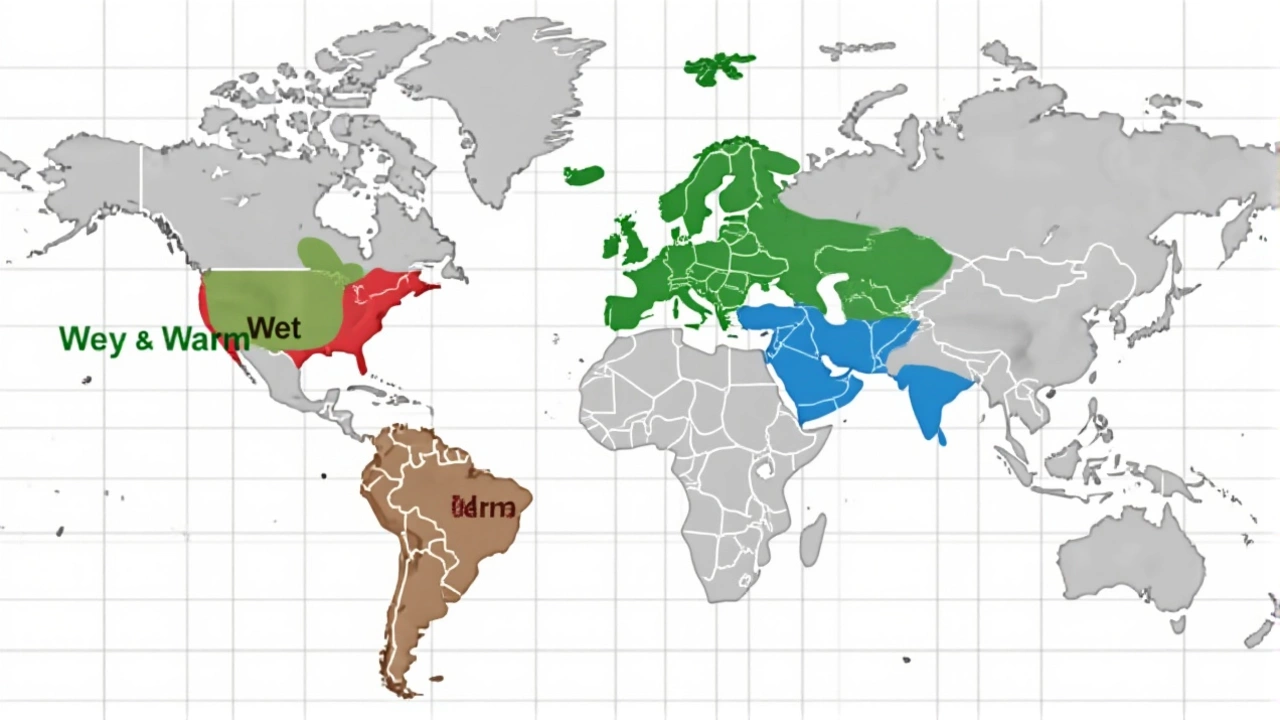
- Southern United States: Expect wetter, colder winters. The Pacific jet stream stretches eastward, dumping rain and snow on California, Texas, and Florida. Colorado typically sees increased precipitation and heavier snowpacks.
- Southeastern South America & Eastern Africa: These areas historically see above-average rainfall. Think flooding risks in Brazil, Argentina, and parts of Kenya and Tanzania.
- Indonesia & Northern South America: The flip side. Below-average rainfall means heightened fire risks and agricultural stress. Indonesia, which relies on monsoon rains, could face severe dry conditions.
- Hurricane Season: Surprisingly, El Niño acts as a hurricane suppressor for the Atlantic. Shear winds chop up developing storms. Historically, U.S. hurricane landfalls drop to about half the frequency seen during La Niña years. Don’t get complacent, though—major hurricanes can still form and pack a devastating punch.
But wait, there’s a twist. Climate change is adding fuel to the fire. Even if the pattern looks like 1998, the baseline temperature is higher now. That means any rainfall comes with more intensity, and any drought starts from a drier, hotter place.
The Watch Window: Summer 2026
We aren’t locked in yet. The next few months are critical. Forecasters at NOAA’s Climate Prediction Center in College Park, Maryland, are watching the summer of 2026 like hawks. Specifically, the May-June-July period.
If easterly trade winds continue to weaken and westerly winds take over, the El Niño will likely establish itself firmly. If the winds hold steady, we might escape the worst of it. Current data shows a 60 percent probability of development during that summer window. It’s a coin toss, but the odds are shifting toward trouble.
The European models are even more bearish, suggesting the event could persist through the Northern Hemisphere winter of 2026-2027. That longevity is concerning because prolonged El Niños tend to have deeper, more entrenched impacts on agriculture and water supplies.
Why This Matters Beyond the Weather Map
This isn’t just about umbrellas and shovels. It’s about food security and economic stability. Droughts in Central and South America threaten coffee, soy, and beef production. Floods in Southeast Asia disrupt supply chains for electronics and textiles. Coral reefs, already stressed by warming oceans, face another round of bleaching events.
Experts warn that the combination of a super El Niño and ongoing anthropogenic climate change could push 2027 air temperatures higher than ever recorded. We’re not just talking about a hot summer; we’re talking about systemic shocks to ecosystems and economies. Insurance markets are already bracing for higher claims, and governments are reviewing disaster preparedness plans.
The details are still evolving. Models change. Winds shift. But the signal is loud enough to ignore. As we head into summer 2026, keep an eye on the Pacific. What happens there echoes everywhere else.
Frequently Asked Questions
When is the peak of the 2026 Super El Niño expected?
The peak intensity is typically expected between November 2026 and January 2027. However, the buildup begins in the summer of 2026, with effects propagating globally throughout the following year. The event may persist through the Northern Hemisphere winter of 2026-2027.
How does El Niño affect hurricane activity in the Atlantic?
El Niño generally suppresses Atlantic hurricane activity by increasing wind shear, which tears apart developing storms. Historical data shows U.S. hurricane landfalls occur at approximately half the frequency during El Niño years compared to La Niña years. However, individual major hurricanes can still form and cause significant damage.
Which regions are most at risk for drought during this event?
Regions typically affected by below-average rainfall include Indonesia, northern South America, parts of Oceania, sub-Saharan Africa, and portions of India. These areas face heightened risks of forest fires, agricultural losses, and water scarcity due to the disruption of normal monsoon patterns.
Why is the 2026 forecast considered a 'Super' El Niño?
A 'Super' El Niño is defined by sea surface temperature anomalies exceeding 3.6 degrees Fahrenheit above average. This is significantly higher than the 0.9-degree threshold for a standard El Niño. Such extreme warmth releases vast amounts of energy into the atmosphere, leading to more intense and widespread global weather disruptions.
What role do trade winds play in forming El Niño?
Normally, easterly trade winds blow warm water toward Asia. During an El Niño, these winds weaken or reverse, allowing warm water to flow back toward the Americas. This shift alters atmospheric pressure and jet stream patterns, driving the global weather changes associated with the phenomenon.


About Author